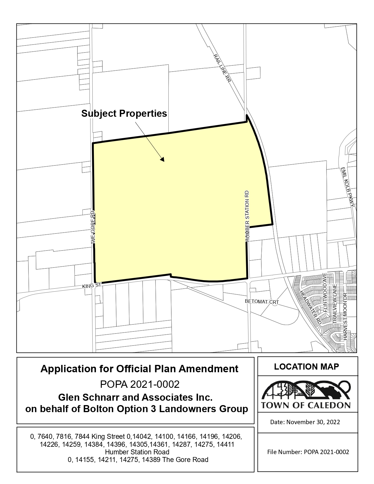
The Town has received a proposed Official Plan Amendment application.
Application and Context
The Town of Caledon has received an application to amend the Town’s Official Plan.
The applicant proposes to expand the Bolton settlement area to establish a mixed-use community on lands north of King Street near Humber Station Road and The Gore Road. The lands are located both within and outside of the 2031 settlement area boundary.
The Secondary Plan area is anticipated to provide a total of 8,670 units, 5,649 of which are within the Major Transit Station Area.
Property Description
The subject lands is located on the East Side of The Gore Road, North Side of King Street and East and West Sides of Humber Station Road.
- Town File Number(s): POPA 2021-0002
- Project Name: Glen Schnarr and Associates Inc. on behalf of Bolton Option 3 Landowners Group
| Location - Ward 6 |
|
0, 7816 and 7844 King Street; 0, 14100, 14166, 14196, 14206, 14226, 14259, 14275, 14287, 14305, 14361, 14384 and 14396 Humber Station Road

|
| Official Plan Amendment |
| A privately-initiated Official Plan Amendment has been submitted which proposes to expand the boundaries of the Bolton Rural Service Centre as described in the Town’s Official Plan. The amendment also proposes to establish a mixed-use community by designating the subject lands to permit a range of residential, commercial, institutional, open space, environmental, mixed and transit hub uses and to establish land use policies for the community.
|
Updates and Notices
| Notices |
|
|
| Material Submitted |
- Cover Letter (Revised)
- Application Form (Revised)
- Preliminary Framework Plan
- 101 – Landownership Map
- 102 – Preliminary Framework Plan
- Planning Justification Report (Revised)
- Macville Community Secondary Plan
- Functional Servicing Report
- Appendix 2, Functional Servicing Report
- Appendix 5, Functional Servicing Report
- Appendix 6, Functional Servicing Report
- Appendix 8, Functional Servicing Report
- Appendix 9, Functional Servicing Report
- Preliminary Water Modelling
- Preliminary Capital Costs, Water and Wastewater
- Preliminary Hydrogeological Investigation
- Preliminary Geotechnical Investigation
- 201 – Pre-Development Drainage Areas to Existing Flow Nodes
- 202-A – Existing Floodplain Mapping, West Humber River Tributary 6 (WHT6)
- 202-B – Existing Floodplain Mapping, West Humber River Tributary 6 (WHT6)
- 301 – Preliminary Grading Plan (1 of 4)
- 302 – Preliminary Grading Plan (2 of 4)
- 303 – Preliminary Grading Plan (3 of 4)
- 304 – Preliminary Grading Plan (4 of 4)
- 305 – Preliminary Earthworks Map
- 306 – Preliminary Road Hierarchy Plan
- 307 – Preliminary ROW Cross Sections (22.9 m and 27 m)
- 308 – Preliminary ROW Cross Sections (22.0 m)
- 309 – Preliminary ROW Cross Sections (19.5 m and 23.0 m)
- 310 – Preliminary ROW Cross Sections (18.0 m)
- 311 – Preliminary ROW Cross Sections (16.0 m and 8.0 m)
- 312 – Preliminary ROW Cross Sections (14.0 m)
- 401 – Channel Cross Sections 1-1 and 2-2
- 402 – Typical Road Crossing Details
- 501 – Preliminary Storm Drainage Areas to SWM Ponds and Flow Nodes
- 502 – Preliminary Minor System Drainage Plan and Storm Servicing
- 503 – Preliminary Major System Drainage Plan and Flow Capture
- 504 – Preliminary Clean Water Collector (CWC) Profile
- 601 – Preliminary SWM Pond 1 Plan View and Sections
- 602 – Preliminary SWM Pond 2 Plan View and Sections
- 603A – Proposed Floodplain Mapping West Humber River Tributary 6 (WHT6)
- 603B – Proposed Floodplain Mapping West Humber River Tributary 6 (WHT6)
- 701 – Pre-Development Drainage Areas to Existing Wetlands
- 702 – Proposed Drainage to Wetlands W1-W6 and Typical RDC Trench Detail
- 801 – Preliminary External Sanitary Servicing Plan
- 802 – Preliminary Internal Sanitary Drainage Plan
- 803 – Preliminary External Sanitary Trunk Profile
- 804 – Preliminary External Sanitary Trunk Profile
- 901 – Preliminary Master Watermain Distribution Plan
- Stage 1 Archaeological Assessment of the Bolton Option 3 Official Plan Amendment
- Comprehensive Environmental Impact Study and Management Plan
- Figure 3.2.5.3a – Headwater Drainage Features
- Figure 3.2.5.3b – HDFA Management Requirements
- Figure 4.8.1 – Comprehensive Constraints and Opportunities Map
- Macville Community Fiscal Impact Study
- Cultural Heritage Resources Assessment Review
- Region of Peel Healthy Community Assessment
- Phase One Environmental Site Assessment, Parcel 1, 14275 The Gore Road
- Phase Two Environmental Site Assessment, Parcel 1, 14275 The Gore Road
- Phase One Environmental Site Assessment, Parcel 4
- Phase Two Environmental Site Assessment, Parcel 4
- Transportation Study
- Macville Urban Design and Architectural Design Guidelines
- Cultural Heritage Impact Assessment
- Housing Assessment
Contact us, or make an appointment to visit Town Hall to view studies not available online, or previous versions.
|
Lead Planner
Tanjot Bal, Senior Planner
Development and Design
905.584.2272 x. 4418
Tanjot.Bal@caledon.ca
Additional resources
For more information about this matter, or to provide comments, feedback or ask questions, please contact the Lead Planner at Town Hall from Monday to Friday, 8:30 a.m. to 4:30 p.m.


 Subscribe to this page