Ward Boundary Review
Notice of Passing By-law 2021-62 to Redivide Town of Caledon Ward Boundaries
In preparation for the 2022 Municipal Election, over the past year the Town reviewed its ward boundary structure to ensure it serves the community and provides effective representation. At the July 13, 2021 Town Council Meeting, Ward Boundary By-law 2021-62 was passed to update the Town's ward structure for the first time in 27 years. The changes to the wards will come into place for the 2022 Municipal Election.
New Ward System
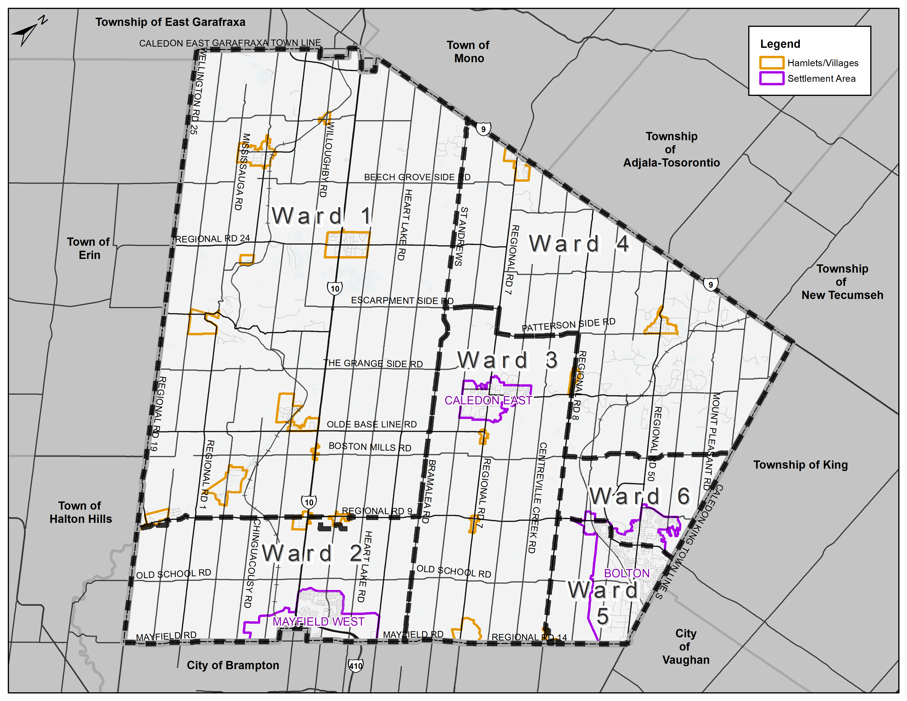
The new structure will include six (6) wards with one (1) Councillor representing each. This prepares for urban population growth while also considering Caledon's rural heritage and communities of interest. The two (2) Regional Councillors who represent the Town on Regional Council will be elected in combinations of wards. One Regional Councillor will be elected to represent wards 1, 2 and 3 and the other will be elected to represent ward 4, 5 and 6. Including the Mayor, Caledon's Council will remain at its current size of 9 Members.
(Please click to enlarge image)
Ward Descriptions and Maps
Presented below are the descriptions and maps from Ward Boundary By-law 2021-62 for each of the wards.
Ward 1 |
|
Description Beginning where the centre line of Highway 9 would meet the centre line of St. Andrews Road if extended, following in a south easterly direction along the centre line of St. Andrews Road to where it meets the centre line of Olde Base Line Road (Regional Road 12). Then following in a south westerly direction to where the centre line of Olde Base Line Road would meet the center line of Bramalea Road if extended. Then following the centre line of Bramalea Road in a south easterly direction to where it meets the centre line of King Street (Regional Road 9). Then following in a south westerly direction along the centre line of King Street until the road reaches the northern edge of the 3749 King Street (ARN #: 212413001007000) property line. Then following east along the property line of 3749 King Street, around the easternmost edge of property lines of ARN #: 212413000621902 and around the south eastern border of ARN #: 212413000621975 to where it meets the easternmost corner of the property line for 13945 Kennedy Road (Regional Road 16) (ARN #: 212413000621905). Then following the edge of the property line to the northernmost corner of the property line around 13945 Kennedy Road and continuing to the north westernmost corner of the property immediately adjacent to Kennedy Road and extending to the centre line of Kennedy Road. Then following across Kennedy Road westward to where it intersects the north eastern corner of 3427 King Street (Roll #: 212413001005400) immediately adjacent to Kennedy Road. Then following along the eastern, southern and western property lines to where, if extended the property line would intersect the centre line of King Street. Then following the centre line of King Street in a south westerly direction to the north eastern corner of 13950 Heritage Road (ARN #: 212412000225100). Then following the easternmost property line of that lot south to the corner and then south west until reaching the south westernmost corner. Then following north until the property line intersects the centre of the Credit River. Then following the Credit River in a south westerly direction to the centre line of Winston Churchill Boulevard (Regional Road 19). Then following the western edge of the municipal boundary, being mostly but not entirely adjacent to Winston Churchill Boulevard, in a northward direction until the municipal boundary intersects with the centre line of Caledon East Garafraxa Town Line. Then following in an easterly direction on the northernmost edge of the municipal boundary to where the boundary would meet the centre line of St. Andrews Road if it were extended, being the point of origin. Map
|
Ward 2 |
|
Description Beginning where the center line of King Street (Regional Road 9) meets the centre line of Bramalea Road, following in a south easterly direction along the centre line of Bramalea Road to where it meets the southern boundary of the municipality at the centre line of Mayfield Road (Regional Road 14). Then following along the edge of the municipal boundary in a south westerly direction to the southernmost corner of the municipality where Mayfield Road meets Winston Churchill Boulevard (Regional Road 19). Then following in a north westerly direction along the westernmost municipal boundary adjacent to Winston Churchill Boulevard to the centre of the Credit River. Then following the Credit River north to where it meets the edge of the property line of 13950 Heritage Road (ARN #: 212412000225100) near the south westernmost corner of that property line. Then from that corner following the property line in a north eastern direction to the corner and northwards to the north easternmost corner of the property line and extending the property line out to where it would intersect the centre line of King Street. Then following the centre line of King Street in a north easterly direction to where it first reaches the adjacent property line of 3427 King Street (ARN #: 212413001005400). Then following south along the westernmost property line of 3427 King Street to the corner and then north east until the property line is adjacent to Kennedy Road (Regional Road 16). Then following north along the easternmost most property line until reaching the property line of 13858 Kennedy Road (ARN #: 212413000611600). Then following in an easterly direction across the centre line of Kennedy Road to the north westernmost corner property line immediately adjacent to Kennedy Road for 13945 Kennedy Road (ARN #: 212413000621905). Then following along the property line in a north easterly direction to the north easternmost corner before continuing to the south easternmost corner adjacent to ARN #: 212413000621975. Then following in a north easterly direction until reaching the south easternmost corner of ARN #: 212413000621902 and continuing in a northerly direction along the easternmost edge of the property line until reaching the property line of 3749 King Street (ARN #: 212413001007000). Then following in an easterly direction to the south easternmost corner of 3749 King Street before continuing in a northerly direction along the property line to where if extended the property line would meet the centre line of King Street. Then following the centre line of King Street in a north easterly direction to where it meets the centre line of Bramalea Road and the point of origin. Map
|
Ward 3 |
|
Description Beginning where the centre line of St. Andrews Road meets the centre line of Escarpment Sideroad, following in a north easterly direction along the centre line of Escarpment Sideroad to the centre line of Airport Road (Regional Road 7). Then following in a south easterly direction along the centre line of Airport Road to where the centre line of that road would meet the centre line of Patterson Sideroad, if it were extended beyond the end of Patterson Sideroad. Then following in a north easterly direction along the centre line of Patterson Sideroad until the centre line of that road meets the centre line of The Gore Road (Regional Road 8). Then following in a south easterly direction along the centre line of The Gore Road until the road meets the western edge of the property line of 12205 The Gore Road (ARN #: 212401000418800). Then following along the property line of 12205 The Gore Road to the northernmost corner and then to the south easternmost corner that meets the edge of 12185 The Gore Road (ARN #: 212401000418700) and along the easternmost boundary of the property lines until 12061 The Gore Road (ARN #: 212401000417750) meets 7540 Mayfield Road (Regional Road 14) (ARN #: 212401000703800). Then following along the north western edge of 7540 Mayfield Road around the adjacent property lines of Mayfield Road between 7540 and 7780 Mayfield Road (ARN #: 212401000702900). Then following along the property line of 7780 Mayfield Road to where it meets the municipal boundary at Mayfield Road and following along the municipal boundary in a south westerly direction until the municipal boundary meets the centre line of Bramalea Road. Then following in a north westerly direction along the centre line of Bramalea Road until the centre line of that road, if extended would meet the centre line of Olde Base Line Road (Regional Road 12). Then following in a north easterly direction along the centre line of Olde Base Line Road to where that centre line would meet the centre line of St. Andrews Road if it were extended beyond the end of St. Andrews Road. Then following in a north westerly direction along the centre line of St. Andrews Road until the centre line of that road meets the centre line of Escarpment Sideroad and the point of origin. Map
|
Ward 4 |
|
Description Beginning where the centre line of St. Andrews Road, if extended, would meet the northernmost municipal boundary edge adjacent Highway 9, following in an easterly direction along the northernmost municipal boundary to where it would meet the centre line of Caledon King Town Line north if it were extended beyond the end of Caledon King Town Line north. Then following in a south easterly direction along the centre line of Caledon King Town Line north until the road ceases in a southerly direction. Then following the easternmost exterior boundary line edge of the municipality in a south easterly direction until the line, if extended, would meet the centre line of 17th Sideroad, being Castlederg Sideroad if extended. Then following in a south westerly direction along the centre line of Castlederg Sideroad to where that centre line meets the centre line of The Gore Road (Regional Road 8). Then following in a north westerly direction along the centre line of The Gore Road to where the centre line of that road meets the centre line of Patterson Sideroad. Then following in a south westerly direction along the centre line of Patterson Sideroad until the centre line of that road, if extended, would meet the centre line of Airport Road (Regional Road 7). Then following in a north westerly direction along the centre line of Airport Road until the centre line would meet the centre line of Escarpment Sideroad if it were extended beyond the end of that road. Then following in a south westerly direction along the centre line of Escarpment Sideroad until the centre line of Escarpment Sideroad meets the centre line of St. Andrews Road. Then following in a north westerly direction along the centre line of St. Andrews Road to where that centre line if extended would meet the northmost municipal boundary line adjacent to Highway 9 and the point of origin. Map
|
Ward 5 |
|
Description Beginning where the centre line of The Gore Road (Regional Road 8) meets the centre line of King Street (Regional Road 9), following in a north easterly direction along the centre line of King Street to where the centre line of that road if extended would meet the centre line of the Emil Kolb Parkway. Then following in a south easterly direction along the centre line of the Emil Kolb Parkway to where the centre line of that road would meet the centre line of King Street west if extended towards Harvest Moon Drive. Then following in a north easterly direction along the centre line of King Street west until it becomes King Street east, then continuing to follow along the centre line of King Street east in an easterly direction until the centre line of that road meets the easternmost municipal boundary along Albion Vaughan Road. Then following in a southerly direction along the municipal boundary until it becomes the southernmost municipal boundary adjacent to Mayfield Road (Regional Road 14). Then following along the municipal boundary in a south westerly direction to the edge of 7780 Mayfield Road (ARN #: 212401000702900). Then following north along the east side of the property line to the properties northern edge. Then following the northern edge of the property line and the northern property line edges of the adjacent properties in a westerly direction until 7540 Mayfield Road (ARN #: 212401000703800). Then following the easternmost property line of 12061 The Gore Road (ARN #: 212401000417750) and the property lines of adjacent lots in a northerly direction until reaching the north easternmost corner of 12205 The Gore Road (ARN #: 212401000418800). Then following the property line of 12205 The Gore Road west to where if extended it would meet the centre line of The Gore Road. Then following in a north westerly direction along the centre line of The Gore Road to where the centre line of that road meets the centre line of King Street and the point of origin. Map
|
Ward 6 |
|
Description Beginning where the centre line of The Gore Road (Regional Road 8) meets the centre line of Castlederg Sideroad, following in a north easterly direction along the centre line of Castlederg Sideroad to where the centre line of Castlederg Sideroad would meet the centre line of Caledon King Town Line south, if it were extended towards Mount Wolfe Road. Then following in a southerly direction along the centre line of Caledon King Town Line south until the centre line of that road, if extended towards Albion Vaughan Road, would meet the centre line of King Street east. Then following in a westerly direction along the centre line of King Street east until it becomes King Street west. Then continuing to follow along the centre line of King Street west in a westerly direction until the centre line of that road, if extended towards Harvest Moon Drive, would meet the centre line of the Emil Kolb Parkway. Then following in a north westerly direction along the centre line of Emil Kolb Parkway until the centre line of that road would meet the centre line of King Street (Regional Road 9) if extended. Then following along the centre line of King Street in a south westerly direction until the centre line of that road meets the centre line of The Gore Road. Then following in a north westerly direction along the centre line of The Gore Road to where the centre line of The Gore Road meets the centre line of Castlederg Sideroad and the point of origin. Map
|


Frequently Asked Questions (FAQ)
|
How will the Mayor be elected? |
|
The Mayor will be elected by general vote at the upcoming Municipal Election in 2022. |
|
When will the wards change? |
|
Subject to an appeal, the new ward structure will officially change on the day the new Town Council is organized following the upcoming 2022 Municipal Election. Please note that the next election will be conducted as though the ward boundary lines have already changed. |
|
Why are there fewer Regional Councillors? |
|
The Town does not have the authority to decide the number of Regional Councillors. In December 2020, Regional Council made the decision to reduce the Town's number of Regional Councillors to two (2) plus the Mayor. Therefore, the Town's Ward Boundary Review did not impact the number of Regional Councillors, but adjustments were made to help address this change. |
|
What ward will I vote in at the next election? |
|
Citizens will vote based on the new proposed ward boundary lines. Although the wards do not officially change until after the next election, the upcoming election will be conducted as though the ward changes have already come into effect. You can use the maps above to find your ward. |
Project Overview To Date
Timeline

Special Town Council Meeting on Updated Final Ward Options - June 28, 2021
At the June 28, 2021 Special Town Council Meeting updates to final ward options were presented to Council for consideration. The updated options were included in a revised Staff Report and presentation provided by the consultant. An option was selected by Council with the intent for a By-law to be brought forward.
Meeting Recording

General Committee Meeting on Final Ward Options - June 14, 2021
At the June 14, 2021 General Committee Meeting the Town's consultant provided a presentation and Final Report that included two final options for consideration. In addition to the Report from the consultant, a Staff Report was available which described the options and other information about the Ward Boundary Review to date.
Final Report Meeting Recording

Round 2 Public Consultation - March 2021
Five preliminary ward options were presented to the public in the second round of consultation. The public engagement sessions were recorded and are available to be viewed through the Council and Committee Meeting page. For residents to learn more, an Information Board was prepared as well as an in depth Preliminary Options Report and Interactive Map displaying the options. A second survey was provided for members of the public to give feedback and select their preferred ward option.
Preliminary Options Report Information Board


Special Town Council Meeting on Preliminary Ward Options - February 1, 2021
A Special Town Council Meeting was held for the Ward Boundary Review consultants to provide a presentation to Members of Council and the public. Results from the first round of public consultation were reviewed and preliminary ward options were shown for consideration and feedback.
Presentation Meeting Recording

Round 1 Public Consultation - November 2020
In the first round of public consultation the Town's consultant provided several presentations for members of the public. This introduced the guiding principles for effective representation and provided background on the Ward Boundary Review. A Discussion Paper was prepared by the consultant for information on Caledon's existing ward system and changing population trends. Members of the public provided feedback through a survey that asked them to evaluate the existing ward system and identify the most important guiding principles.
Round 1 Presentation Discussion Paper


Background Information
Watch our video about the Ward Boundary Review
Frequently Asked Questions (FAQ)
|
What is a Ward Boundary Review? |
|
A ward is a municipal unit of representation that is equivalent to a constituency (or riding) at the provincial and federal levels. A Ward Boundary Review is a task conducted on behalf of a municipality to assess whether the present wards constitute an effective and equitable system of representation and, if not, to propose alternatives. |
|
What is the System of Representation in Caledon? |
|
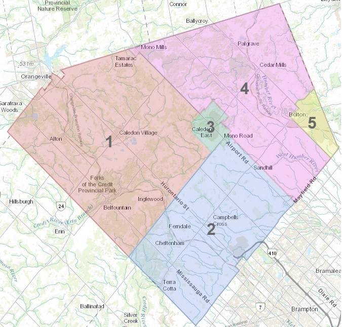
The Town of Caledon was established under provincial legislation at the beginning of 1974 as a lower-tier municipality in the Regional Municipality of Peel. The present municipality is an amalgamation of the former Townships of Albion, Caledon and the northern half of Chinguacousy, as well as the Villages of Bolton and Caledon East. As part of the amalgamation, the former police villages of Alton, Caledon, Inglewood and Palgrave were dissolved. Caledon is governed by a nine-member Council, composed of a Mayor, four Regional Councillors, plus four Councillors. Recently, the Regional Council representation in Caledon was reduced from 5 to 3 which will take effect as part of the 2022 term of Council. As a result of an Ontario Municipal Board order of January 28, 1994, the Town was divided into five wards, with Wards 3 and 4 represented by one Regional Councillor and one Councillor. The boundaries approved at that time have not been modified. |
|
Why is Caledon conducting a Ward Boundary Review? |
|
The electoral boundaries used in federal and provincial elections in Canada are reviewed on a pre-determined cycle; for example, seats in the House of Commons are subject to redistribution after each Census (that is, every ten years) to take account of population changes. A review of the electoral arrangements in Ontario municipalities is discretionary; the obligation to undertake a review of municipal electoral districts is entirely absent from legislation. The ward boundaries in Caledon have not been reviewed since 1994. Caledon’s population has grown by approximately 59% since the existing wards were created. Wards designed to reflect the population in 1994 need to be reassessed in light of the larger population today to ensure that representation remains consistent with democratic values. Furthermore, population growth has not been uniform across Caledon and will be concentrated in urban settlements over the next decade. As a result, there is a significant variation in the population between the smallest of the existing wards and the largest. The Town of Caledon should aspire to a ward system that provides fair representation to all of its residents. With an election looming in 2022, in accordance with the Municipal Act, 2001, any changes to the Town's Ward Boundaries will need to be in place by January 1st of that year. |
|
Who is conducting the Caledon Ward Boundary Review? |
|
Given the political importance of the ward boundaries, a review that would be considered acceptable by the community and by Local Planning Appeal Tribunal (LPAT) should not be conducted for the municipality by someone who is a member of Council or a municipal employee. The Town has retained Watson and Associates and Dr. Robert Williams to conduct a comprehensive and independent Ward Boundary Review through a process set out in a report to Council in February 2020. Together the consultant team has conducted over twenty ward boundary reviews in Ontario and will utilize their experiences gained through those reviews to assess the present electoral arrangements in Caledon and to design alternatives consistent with the guiding principles for the Review. |
|
How will the Town's Ward Boundary Review be conducted? |
|
The consultant team will direct the Ward Boundary Review process for the Town and will gather background information on the present ward system from interviews with Town staff and elected officials. The consultant team will also compile data on the present and projected population of the Town. Based on that research, the consultants will assess the present ward boundaries and develop alternative designs consistent with the guiding principles for the review (see below). Public consultation is essential for the review process to be legitimate and effective and will be undertaken through a number of mediums and forums. The primary goal is to ensure that members of the public are provided with opportunities to:
Due to the public health emergency, Public Engagement Meetings will be held in a format that provides for the safety of the public during the COVID-19 pandemic. A Final Report will be submitted to Council for consideration as pursuant to the the Municipal Act, 2001 the statutory authority rests with municipal Council to:
|
|
What will be considered in the Ward Boundary Review? |
|
The objective of the Ward Boundary Review is to evaluate the suitability of the present wards and consider alternative designs that are consistent with the following guiding principles determined through a Supreme Court of Canada decision (The Carter decision). Effective RepresentationThe Supreme Court of Canada determined that parity of voting power was a prime but not an exclusive condition of effective representation. Deviations can be justified where factors, such as geography, community history, community interests and minority representation would result in a legislative body that was more representative of Canada’s diversity. According to the Court, considering all these factors provides effective representation. Representation by PopulationVoters should be equally represented, and wards should have reasonably equal population totals. Voter parity should be the goal of ward boundary reviews. Population size variances of between plus or minus 25 to 33 percent are generally accepted as the maximum variance to achieve voter parity. Communities of InterestThe Carter decision recognizes that the protection of communities of interest may justifiably override the principle of voter parity where the inclusion of a community of interest will lead to a system that is more representative of the Town’s diversity. The Court did not define what constitutes a community of interest; however, it has been leveraged in Ontario Municipal Board appeals to recognize historical settlement patterns or existing communities and to represent social, historical, economic, religious, linguistic or political groups. Future Population TrendsWard Boundary Reviews should consider future changes in ward population. Being mindful of anticipated population trends will ensure that a ward and its residents are neither advantaged, nor disadvantaged because of development activity throughout the town. Ward Boundary Reviews should take into consideration anticipated changes in population of a period of twelve years, or three elections. Physical and Natural BoundariesWard boundaries will be drawn impartially and with consideration to using distinct physical and geographic features. Physical features should be leveraged as they create preexisting boundaries which naturally divide Town residents and may facilitate the effective representation of the ward’s residents. |
|
Is there an appeal process? |
|
Section 222 of the Municipal Act, 2001 provides that within 45 days after a By-law is passed to divide, re-divide or dissolve wards, a person may make an appeal to LPAT by filing a notice of appeal with the municipality setting out the objections to the By-law and the reasons in support. The municipality will forward any notices of appeal to LPAT. |
Town Ward System and Council Information
Composition - The Town is divided into five Wards (see map on the right). Each Ward has two representatives, a Councillor and a Regional Councillor, with the exception of Wards three and four, which share one Councillor and one Regional Councillor. Councillors represent their Wards at Town of Caledon Council meetings while Regional Councillors represent their Wards at both the local level and at the Region of Peel.
Election - Electors in each Ward can choose only among the candidates who are running for election in their specific Ward. The Mayor is the head of Council and is elected at-large by all eligible electors in the municipality (the Mayor is also a member of Regional Council).
Mayor and Council
Mayor Allan Thompson
Ward 1
Regional Councillor Ian Sinclair
Councillor Lynn Kiernan
Ward 2
Regional Councillor Johanna Downey
Councillor Christina Early
Ward 3 & 4
Regional Councillor Jennifer Innis
Councillor Nick deBoer
Ward 5
Regional Councillor Annette Groves
Councillor Tony Rosa
Contact Us
 Subscribe to this page